The perimeter of Monte Gallo coincides with important structural features that give rise to high and steep cliffs, sub-vertical or overhanging on the sea side, affected by fall phenomena due to the presence of a dense network of tectonic discontinuities, attributable to different fault systems, which isolate blocks of different shapes and sizes in conditions of instability. These instability conditions due to tectonics are exacerbated by the presence of excavations and niches caused by marine erosion and karst caves remodeled by the action of the sea. In this geomorphological context fall phenomena develops, which in many cases can directly involve the urban fabric and the road network that develop on the slopes of Monte Gallo.
According to the report “Piano Stralcio di Bacino per l’Asseto Idrogeologico (PAI, 2004), Metodologia operativa per l’analisi e la valutazione del rischio geomorfologico”, the hazard is assessed as the actual state of danger of a place for the presence of landslide phnomenon. In the evaluation of landslide hazard, these play a determining role: 1) the intensity or magnitude (M) understood as the mechanical and geometric “severity” of the potentially destructive phenomenon; and 2) the state of activity, which provides a temporal assessment and therefore of the propensity.
To give an estimate of the landslide phenomenon intensity, the extent and/or volume of the landslide and its type are related. To determine the state of activity of landslides, the following classification was adopted: 1) active or reactivated; 2) inactive; 3) quiescent; 4) artificially or naturally stabilized.
Falls, regarding the state of activity, are considered differently from the other types of landslides. Considering that these phenomenologies are one of the most unpredictable and therefore most dangerous, it was decided to consider them “active”, delimiting however, the actual source area of the rock detachments. From the correlation between magnitude and the state of activity it is possible to obtain an indicative evaluation of the hazard, identifying 5 classes of hazard, from P0 to P4.
Furthermore, the cartographic perimeter for falls does not coincide with the perimeter relative to the failure, but it has been calculated, in precautionary terms and where there are no particular situations, a width band equal to 20 m that corresponds: 1) upstream, to the area of potential danger due to receding of the rock face as a result of detachment phenomena, while 2) downstream, the propagation area of the detached rocks has been identified, hypothesizing according to the morphological characteristics of the downstream areas and according to the distribution of the collapsed rocks, and of the data when available, deriving from the statistical calculation of all possible trajectories.
In order to arrive at the final risk assessment, it was searched a definition and evaluation of the vulnerable elements that were easy to apply and adaptable to the Sicilian territorial reality. In the definition of expected damage, the following are evaluated: 1) risk elements (E), represented by the population, housing, economic activities and cultural heritage that may suffer damage as a result of the occurrence of the phenomenon; and 2) their vulnerability, understood as the degree of loss produced on a certain element or group of elements exposed to risk, resulting from the occurrence of a natural phenomenon of a given intensity.
Therefore, through the combination of hazards P and risk elements E, the final risk is determined.
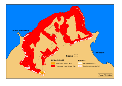
Along the slopes of the calcareous-dolomitic nature of Monte Gallo, several falls are located giving rise to high hazard areas (P3) or very high hazard areas (P4) depending on the extent of the failure itself. The aforementioned dangerous areas include some areas of the inhabited areas near Mondello, Pizzo Sella, between Tommaso Natale and Sferracavallo and Partanna Mondello, a shipyard, the lighthouse of Capo Gallo, all areas at very high risk (R4) and some stretches of municipal roads and scattered houses in different areas of Monte Gallo and Pizzo Sella are high risk (R3) (Figure 1).

HIGH RISK (R3): problems are possible for the safety of persons, functional damage to buildings and infrastructures, the interruption of socio-economic functionality activities and significant damage to the environmental heritage.
VERY HIGH RISK (R4): the loss of human lives and serious injuries to people are included, serious damage to buildings, infrastructure and environmental heritage, the destruction of socio-economic activities are possible.
